
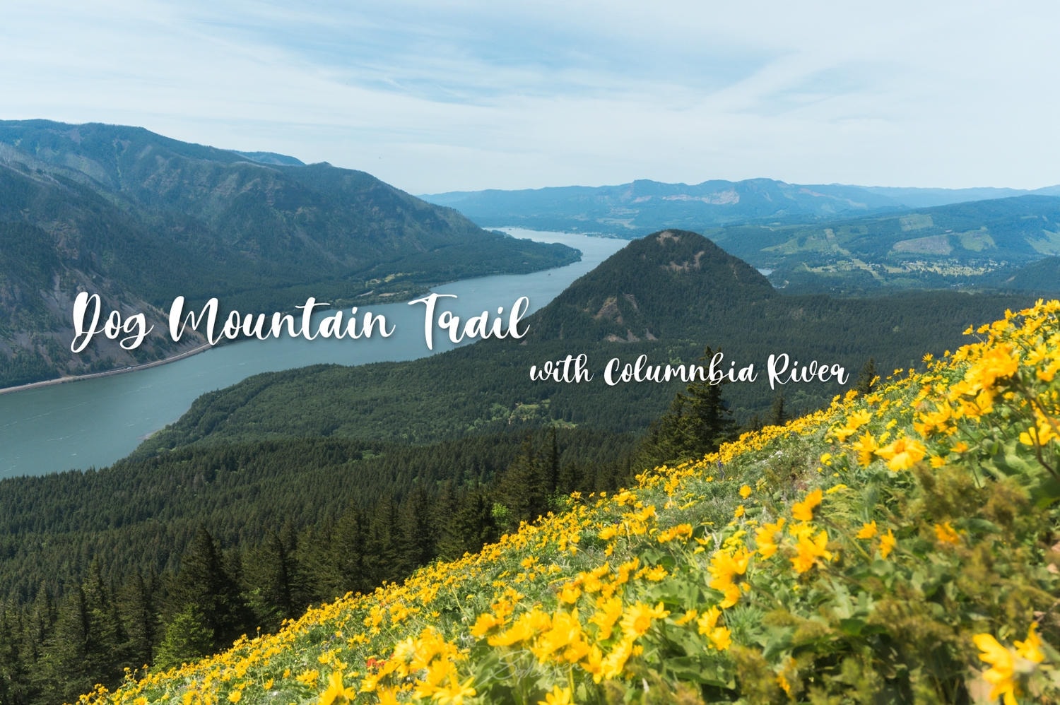
The Dog Mountain hike is one of the best wildflower trails near Portland: a roughly 6-mile, 2,800-foot climb in Washington’s Columbia River Gorge, famous for hillsides of golden balsamroot from April to June. I went completely underprepared. Permits were sold out, my partner and I shared a single water bottle for almost five hours, and I nearly followed the wrong trail (one with the same name sits in Canada). This guide covers how the permit system works, how to ride the free shuttle when permits are gone, what the climb is actually like, three nearby wildflower hikes worth adding, and exactly what to pack so you don’t repeat my mistakes.

What Is Dog Mountain (and Why Are Permits So Hard to Get)?
“Do I really need a permit for Dog Mountain?” was the exact question keeping me up the night before. Short answer: Dog Mountain is a strenuous wildflower hike in the Columbia River Gorge National Scenic Area, about 6 miles round trip with nearly 2,800 feet of elevation gain, rated Hard on AllTrails and taking most people 4 to 5 hours. Permits are so hard to get because every spring the summit meadows explode with balsamroot, mixed with purple lupine and red paintbrush, and half the Pacific Northwest wants to see it on the same three weekends.
It started, honestly, with a photo on Instagram: a hillside covered in yellow, the Columbia River below, Mount Hood in the background. I sent it to my partner and said I wanted to go that weekend. Very spontaneous, very underprepared, and I found out the night before that the permits were already gone.
The trail sits in a transition zone between wet Pacific Northwest forest and the drier landscapes east of the Cascades, so the scenery shifts as you climb. On a clear day you can see Mount Hood, Mount St. Helens, and Mount Adams all at once. I wasn’t expecting that, and it was one of those moments where you just stop talking.
Getting There from Portland
The trailhead is right off Highway 14 at milepost 53.7, an easy hour’s drive from Portland. The parking lot fits only about 70 cars, and on wildflower-season weekends it fills before 10am, so start early. Most people cross the Columbia River via the Bridge of the Gods, a toll bridge that costs $3 cash or $1.25 with a BreezeBy tag. The trail is popular enough that hikers make the four-hour drive down from Seattle just for the bloom.
Do You Need a Permit?
Yes, on spring weekends you do. During peak wildflower season (in 2026, that’s April 11 to June 7 on weekends, plus Memorial Day, May 25), you need a timed-entry permit through Recreation.gov for $2 per vehicle, non-refundable, and rangers check on the trail. Parking is a separate $5 per vehicle year-round, covered by a Northwest Forest Pass or America the Beautiful Pass.
Here are your three ways in, side by side:
| Entry option | Permit needed | Parking | Cost | Best for |
|---|---|---|---|---|
| Weekend, self-drive | Yes (Recreation.gov) | Grab your own (~70 spots) | $2 permit + $5 parking | Early risers who snag a permit |
| Weekend, free shuttle | No (given on board) | Free at Fairgrounds | Free | Anyone who missed the permit |
| Weekday | No | Much easier | $5 parking | Flexible schedules |
When I tried to book the night before, everything was gone, so I took the backup: the free shuttle. Columbia Area Transit (CAT) runs it from the Skamania County Fairgrounds in Stevenson; boarding the bus counts as your permit for the day, and they stamp a little dog paw on your hand as proof. The bus is called CAT, the trail is Dog Mountain, and the stamp is a paw print. Someone clearly had fun with the naming.
One local tip: rangers usually clock off by mid-afternoon, so arriving after 2 to 3pm often means no one is checking permits; by then a lot of hikers have also come down, so parking can actually free up, and if you time it right you can catch sunset over the river on the way down. Just remember the light fades fast, so pack a headlamp. Going on a weekday skips the permit entirely and makes parking far easier.
Shuttle timing matters: the last bus to Dog Mountain leaves the Fairgrounds at 1:00pm, and the last bus back leaves Dog Mountain at 5:00pm. If you hike slowly (we took five hours round trip), catch an early one so you’re not rushing the descent.

The Hike Itself
The climb starts steep and stays that way. A little past the 0.6-mile mark you hit a fork signed “Difficult” and “More Difficult,” which is as blunt as it sounds; most people go up More Difficult (faster) and down Difficult (kinder on the knees) to make a loop.
People often ask me: can a beginner actually finish this? Honestly, yes, but go in prepared. We were already winded after the first section, so we took Difficult both ways, and that route up is a steady, manageable grade. There’s a rest spot before the two routes meet where balsamroot starts to appear and the gorge opens up. Keep going past Puppy Dog viewpoint to the top: the wildflowers, the river, and Mount Hood all arrive at once. I stood there a long time and did not want to leave, hot and shadeless as it was. The summit has room to spread out and eat, and you’ll see plenty of leashed dogs. (If you play Pikmin Bloom, there are three mushrooms along the way.)

More Wildflower Hikes in the Columbia River Gorge
If Dog Mountain is full or too steep for your legs, the Gorge has more than 800 blooming species every spring, and several trails make an easy plan B. Here’s how the main ones compare:
| Trail | Distance | Elevation gain | Difficulty | Dogs | Parking |
|---|---|---|---|---|---|
| Dog Mountain | ~6 mi | ~2,800 ft | Hard | Yes (leashed) | Very limited |
| Rowena Crest / Tom McCall Point | 2.5–4 mi | up to ~1,070 ft | Easy–Moderate | No | Moderate |
| Catherine Creek | ~2–3 mi | Minimal (paved option) | Easy | Yes | Easy |
| Coyote Wall | Flexible | Variable | Moderate | Yes | Moderate |
Rowena Crest (Oregon side) is probably the most photogenic spot after Dog Mountain, with similar balsamroot scenery and far less climbing. Catherine Creek (Washington side) is the easy, early-season option, with a paved universal-access loop. Coyote Wall lets you go short or long, on fully exposed slopes (bring sun cover; poison oak and rattlesnakes are present). If you’re already driving out, Rowena Crest is only 30 minutes east: early morning on Dog Mountain, afternoon at Rowena makes a genuinely good day.

Our Mistakes (Please Learn From These)
We went in thinking it was a two-hour trail, my partner left his water bottle in the car, and we shared one bottle for almost five hours. Not smart. Bring enough water for everyone: the lower trail has shade, but the viewpoint and summit have none, and you’ll go through it fast on a sunny day.
The other lesson is trekking poles. Up was fine without them; down was punishing on the calves and toes. We ended up grabbing two sticks off the ground halfway, and the difference was instant. And watch for the AllTrails trap: search “Dog Mountain Trail” and two results appear. I saw one listed at 1 to 2 hours and thought it was ours; my partner looked closer once we were already hiking and realized that one is in Canada. Double-check you’re on the Washington State version before you go.
What to Pack, and Who Dog Mountain Is For
Pack these before you go:
- 1.0L+ of water per person, non-negotiable
- Real food (energy bars, snacks, a sandwich; nearly 3,000 feet of climbing is real work)
- Trekking poles, especially for the descent
- Sunscreen, hat, sunglasses (no shade up top)
- Hiking shoes with grip
A few more things to know: poison oak grows in the lower sections (leaves in threes, don’t touch plants off-trail); the trailhead warns of ticks and rattlesnakes; biting flies find you the second you stop for a photo; there’s a vault toilet about 400 feet up (you’ll know when you see it); and cell service is surprisingly solid most of the way.
So who is this hike for?
- Great for: hikers with moderate fitness, anyone up for an early start or the shuttle, and people who want wildflowers plus a three-volcano view in one day
- Not great for: total beginners who’d rather not prepare, anyone with bad knees, or those hoping for a flat, shady stroll (this is a genuinely Hard trail)
Planning a bigger Pacific Northwest spring trip? It pairs well with cherry blossoms at Oregon’s State Capitol Park, the giant Thomas Dambo forest trolls around Portland and Seattle, or a slower detour out to Bend, Oregon.
Frequently Asked Questions
Do you need a permit for the Dog Mountain hike?
On spring-weekend dates you do. In 2026 that's April 11 to June 7 on weekends plus Memorial Day; you need a $2 timed-entry permit from Recreation.gov, plus a $5 parking fee. Weekdays and off-season need no permit.
What if Dog Mountain permits are sold out?
Take the free shuttle. Columbia Area Transit (CAT) runs it from the Skamania County Fairgrounds in Stevenson on spring weekends. Boarding counts as your permit for the day, parking at the Fairgrounds is free, and no reservation is required.
How hard is the Dog Mountain hike? Can beginners do it?
AllTrails rates it Hard: about 6 miles with nearly 2,800 feet of gain, 4 to 5 hours, mostly uphill. Beginners can finish it, but bring plenty of water and food, pace yourself, and use trekking poles for the descent.
When is the best time to see wildflowers on Dog Mountain?
Peak season runs April through June, with the golden balsamroot usually best from mid-May to early June, alongside purple lupine and red paintbrush. Bloom timing shifts yearly, so check the NW Wildflowers bloom map before you go.
Can you bring dogs on Dog Mountain?
Yes, on a leash the whole way. You'll see plenty of dogs at the summit. Just note the trail is steep and exposed with little shade, so bring enough water for them in warm weather.
📍 Carson, WA 98610 — off Lewis and Clark Highway / Highway 14, Milepost 53.7 (Google Map)
⏰ Open year-round
💰 Parking: $5/vehicle (Northwest Forest Pass or America the Beautiful Pass accepted)
🎫 Permits (wildflower season weekends, approx. April–June): Recreation.gov
🚌 Free Shuttle Bus: Columbia Area Transit (CAT) — departs from Skamania County Fairgrounds, 520 SW Rock Creek Dr., Stevenson
🌸 Wildflower bloom status: NW Wildflowers Bloom Map
🌐 Official trail info: USDA Forest Service

Hi BFFs!
The article may contain affiliate links, and we welcome you to book accommodations or purchase tickets through the links in the article or below. Rest assured, it won’t affect the price for you, but it would give us a small commission to support us in creating more great content. Thank you so much for your support!
✒︎ Flights: Skyscanner
✒︎ Accommodations: Booking.com, Agoda
✒︎ Tickets: Klook, KKday, Get Your Guide
✒︎ Car Rentals: Rental Car
✔︎ Shh! Just Tell You exclusive travel discount code.
All opinions on this website are 100% personal and I only recommend products or itineraries that I trust. Please refer to the “Disclosure and Public Welfare Program” section for more details. If you have any questions, please click on the social media icons below to contact me, or email 📧 to [email protected].
All copyrights of the blog’s texts and images are reserved. Link sharing is welcome. © 2018-2026 Shh! Just Tell You.

Sophie Yen
Taiwanese travel blogger based in the U.S. | Shh! Just Tell You
I work a 9-to-5 like most of us and write about travel after hours. Instead of racing through checklists, I prefer staying longer in one place. Everything on this blog comes from hotels I have actually stayed at, streets I have walked, and the honest research I do before every trip.